Plot your paradise with new Garmin Navionics+ marine cartography
Feb 1, 2022
New marine cartography from Garmin delivers all-in-one inland and coastal mapping, access to daily chart updates, new Auto Guidance+ technology and more to Garmin chartplotters.
Garmin® International, Inc., a unit of Garmin Ltd. (NYSE: GRMN), the world’s largest1 and most innovative marine electronics manufacturer, announced on January 19th, Garmin Navionics+™ and premium Garmin Navionics Vision+™ for Garmin chartplotters, the newest generation of marine cartography products from Garmin. Wherever mariners choose to plot their paradise, new Garmin cartography products offer an all-in-one mapping solution that integrates detail-rich inland and offshore content, as well as a variety of tools to support smarter and safer navigation.
“Garmin Navionics+ and Garmin Navionics Vision+ offer our best and most feature-rich marine cartography experience to date – a true game-changer for boaters and anglers,” said Dan Bartel, Garmin vice president of global consumer sales. “Now, with new coverage regions, mariners have the freedom to confidently explore inshore and offshore waters with a full suite of mapping content and advanced features. Plus, with access to daily chart updates, mariners can stay informed about the latest changes to their maps and charts and benefit immediately from new cartography releases.”
In addition to unparalleled worldwide coverage and No.1 marine mapping1, new Garmin cartography offers a myriad of features – including an all-new chart presentation, daily chart updates and advanced autorouting capabilities – that are designed to smoothly guide boaters on the water, or quickly lead anglers to where the fish may be hiding. It also features color-shaded target depth ranges, up to 1-foot depth contours, free downloadable NOAA raster images2, shallow water shading and exclusive access to ActiveCaptain community content for valuable insight on points of interest (POI), recommendations and advice from fellow boaters.
Here’s what’s new with Garmin cartography:
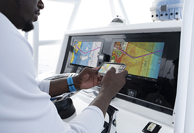
New, redesigned chart presentation
Garmin Navionics+ and Garmin Navionics Vision+ introduce an improved look and feel – with vivid color palettes and greater detail of coastal and inland features – to deliver a new, on-screen cartography presentation for more intuitive navigation on lake or sea. This new interface displays charts in striking detail with a crystal-clear look at the depths below the boat, as well surrounding structure and navigational aids above the waterline.
Up to 5,000 daily updates
With up to 5,000 updates to chart content every day, Garmin’s new cartography products offer the latest insights about any body of water for enhanced situational awareness and peace of mind while navigating. Daily chart updates combine millions of contributions from private and public surveyors, crowd-sourced data and more, delivering the freshest, most up-to-date content each time mariners leave shore. With coverage of more than 42,000 lakes worldwide, daily updates allow for immediate access to new chart data and lake content as it is released. A one-year subscription is included with the purchase of Garmin Navionics+ or Garmin Navionics Vision+ and offer a quick-and-easy way to sync a mobile device to Garmin chartplotters for unlimited daily updates via the ActiveCaptain® smart device app.
Advanced autorouting technology
New Garmin cartography also includes Auto Guidance+ technology3 with faster route calculations and improved routing detail. After selecting departure and arrival points, Auto Guidance+ considers a variety of factors – overhead clearance, chart data, popular routes and desired depth – then creates a suggested route for mariners to follow to their destination.
See more with premium Garmin Navionics Vision+ content
For more advanced features, boaters and anglers can upgrade to premium Garmin Navionics Vision+ to discover more about the coasts they cruise or lakes they fish. Premium Garmin cartography includes all the standard features found in Garmin Navionics+, with the addition of high-resolution relief shading, sonar imagery, unique 3D views, high-resolution satellite imagery, aerial photography and more.
Garmin Navionics+ and premium Garmin Navionics Vision+ can be purchased via download or microSD card for compatible Garmin chartplotters with suggested retail prices ranging from $129.99 USD to $399.99 USD, based on varying coverage. Compatible chartplotters with built in g3 cartography can convert to Garmin Navionics+ content with the purchase of an update microSD card; Simply install the update card to receive the enhanced content and gain access to daily updates.
Garmin Navionics+ and Garmin Navionics Vision+ are compatible with current Garmin chartplotters, including the GPSMAP® 8400/8600, GPSMAP 7×3/9×3/12×3, ECHOMAP™ Ultra, ECHOMAP UHD series and more. Previous chartplotter models, such as the GPSMAP 7×2 Series, will continue to have access to updates of Garmin BlueChart g3 coastal charts and LakeVü g3 inland maps with Navionics data via download or microSD card purchase. For more information about Garmin cartography and chartplotter compatibility, click here.
1 Based on 2020 reported sales.
2 Raster cartography cannot be viewed on echoMAP™ CHIRP and ECHOMAP™ Plus combos but can be viewed on mobile devices via the ActiveCaptain mobile app
3 Auto Guidance+, Auto Guidance and Dock-to-Dock Autorouting are for planning purposes only and do not replace safe navigation operations